Sun 2 Apr 2017
For a full index of the walks, please click here
 |
Grayrigg Common from the Kendal-Tebay road
|
"Many times driving south along the M6 through the Lune gorge I have been struck by the impressive crags of Grayrigg Common over to the right. I have long wanted to try the ridge which ascends from the A685 road Kendal to Tebay. It appeared to be an obvious route to the top of the fell but Wainwright doesn’t show it in his notes on the Whinfell Range."
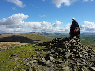
I wrote that in September 2012, and completed the walk. And now almost five years later Andrew and I planned to go up there on a beautiful warm and sunny day. Andrew drove to the small lay-by at the entrance to Lower Borrowdale, and we both set off on foot up the road to the car park overlooking the M6. The vague path up the rib between Little and Great Coums was steeper than I remember it, the last part being particularly so, but in fact we were at the cairn on what the OS calls Grayrigg Pike in no time.
 |
Cairn on Grayrigg Pike
|
The wonderful views over the Howgills were as clear today as before, and very satisfying.
 |
Wainwright's sleeping elephants - The Howgills
|
 |
Low Borrow Bridge Roman Camp (vacated)
|
We then walked westward to the gate in the wall, found a spot out of the light breeze, and relaxed over our lunch in the warm sunshine. Suitably refreshed we took a faint path that led us on to the summit of the fell and took some photos. In the previous autumn someone had lowered a small metal container at the end of a nylon thread down inside the trig column, and on opening it there was a roll of paper with a name on it - Burton! I wrote our names on it with the date and lowered it back down.
 |
Summit of Grayrigg Common
|
We then set off westward over the broad top of the fell with superb panoramic views, making for a radio mast which is linked by road to the original one. From the latter
the top of Whinfell seemed a long way away, but it was only about half past one so we had plenty of time left, and we found an intermittent path leading over the grass towards it. We saw someone descending, and soon we met him on the path and chatted. He lived at Natland where a sometime colleague of mine, John Kingdon, came from. I wasn't keen on climbing up all the way to the beacon but after I had started I was determined to finish, taking deep breaths all the way. I was disappointed to find that there is now but one cairn when there used to be three. Over many years some of the stone from the other two have been fashioned into a low windbreak. It was lovely to be up there again, looking south down towards Whinfell Tarn and beyond to Paton and Mealbank.
 |
Whinfell Beacon
|
We descended, still in the sunshine which had blessed our walk all the way so far.
The trackway down to the farm road in Borrowdale was predictably very wet in places. We found two of the old culverts I had noticed on one of my earliest forages along this track on 1 March 1980, now almost hidden in grass and covered with moss.
 |
End of culvert on lower side of trackway
|
 |
A dry section of the raised trackway (see text)
|
The Roman Fort at Low Borrow Bridge is thought by some to have had a road link to Watercrook which went over the col between Whinfell and Grayrigg Common, and in the CWAAS* transactions there is an article by Eric Birley, F.S.A. about it. In it he quotes an earlier account where it is stated that the road 'is formed in a very durable and substantial manner, it is raised above the ordinary level of the surrounding ground; it has been paved, channelled, and thoroughly drained, and has been dry and hard, and available for a rapid and heavy traffic in all weather.'
It hasn't been anything like that for many years and today it would take some mighty digging to discover any hard surfaces apart from the covers to the above-mentioned culverts. It would be interesting to have it properly excavated though.
In 1981 Wainwright asked two experts on Roman roads (John Marsh and John Anstee) about it and wrote to me saying that the former agreed the track is Roman, and the latter didn't, and as far as I know it's still unresolved.
 |
Lower Borrowdale from the 'Roman Road'
|
Down on the farm road in the valley it is noticeable how that surface also has deteriorated. I took photos of the strange ripples in a huge rock and a twisty tree against the sky, as I had done on the occasion when passing them on a walk on 22 September 2012.


